NORTHERN WASHINGTON

A SOBO hiker attempts to cross a steep section of snow between Red and White Pass
NORTHERN WASHINGTON
"Everybody has a plan until they get punched in the mouth." - Mike Tyson
Starting the PCT in Northern Washington can be a risky venture even for experienced hikers. Three dangerous physical obstacles stand in your way - Rock Pass (between Harts Pass and the border), Glacier Peak Wilderness, and Red and White Pass (In Glacier Peak). In addition to this you can include rain and snow storms, constant wetness/dampness, many steep snow crossings, countless downfall trees across the trail, and extreme elevation changes.
What most people don't know is that Northern Washington features even more elevation change than the Sierra. In the 240 miles between Tuolomne Meadows and Southern Kennedy Meadows (the Sierra), the PCT rises about 43,000 feet and falls 45,000 feet. In the 240 miles heading south from the US/Canadian border to just before Snoqualmie Pass, the elevation change is up 57,000 feet and down 57,000 feet. Almost half of that is the 107 miles stretch between Stehekin and Stevens Pass, most of Section K, which is +29,000/-27,000 feet.
Unmelted snow in Northern Washington makes mountain passes treacherous to cross, and can linger on parts of the trail even until August. Below are explanations of the most dangerous passes. Coincidentally, all are within the first 150 miles of the trail, making the start especially treacherous. Eastwood (SOBO '16) has a great, detailed description of Rock Pass and Red/White Pass with multiple pictures on his website. You can find them here - Must Like Walking.
Looking for when to start your PCT southbound thru-hike? You can find that on our Starting the Trail page.
MAPS AND APPS
If you encounter extended snowfields in Northern Washington the trail might become difficult to follow. With the retirement of the Halfmile app, Guthook's PCT likely your best option. If you ever get lost the app can use GPS (no cell service needed) to point you toward the PCT. Most hikers ditch the paper maps for the app, keep their phone on airplane mode, and carry a backup battery. Even with this remarkable technology remember that your phone can easily get wet or drop and break. Consider carrying a backup system (i.e. paper maps and compass) especially at the beginning and if you're hiking alone.

Rock Pass isn't the path to the right. It's that snowy cliff looking precipice in the left background
ROCK PASS
This steep and snow covered slope is likely the most dangerous part of the trail between Hart's Pass and the US/Canadian border. The conditions of this pass vary greatly depending on time of day and time of year. When Happy Feet hiked through this part, he was assured by a fellow hiker that the snow fields were entirely frozen, and crampons were needed. The next day he found the snow on the pass thawing, and it was relatively easy to kick in footholds. A week earlier Eastwood, an AT '14 thru-hiker, had almost turned around at this pass because of the possible danger.
It's likely that steps will already be made through most snow sections you encounter. Your most valuable skill will likely be kicking safe steps, and judging whether or not the existing steps are safe enough to use. Here's a video on kicking steps - note that with a backpack you'll be moving much slower, and will likely have to kick a step a few times in order to make a safe hold. You'll also have much lighter shoes than this mountaineer's heavy boots, making the process more time consuming.

Clouds, fog, and late July snow in the Glacier Peak Wilderness - 2016
GLACIER PEAK Wilderness
Often Glacier Peak Wilderness ranks as one of hiker's favorite parts of the trail. Likely no one actually thinks that as they are hiking through this monster of a section. High or low lights depending on your opinion include a 4,000 foot gradual climb on a hopelessly overgrown trail near Agnes Creek, a difficult 2,500 foot, similarly overgrown descent to Milk Creek and climb back up the other side, large snowfields around Fire Creek Pass, and harrowing conditions after the Chuck White River between Red and White Pass - described below. All this and a whopping 107 miles between Stehekin and Stevens Pass. There's a lot of debate as to what makes a thru-hiker, but this much is true - braving the dangers of Glacier Peak is an important part of the SOBO experience, and adventures here will be talked about throughout the trail. Read about Happy Feet's experience in Glacier Peak in this PCTA Blog entitled "A SOBO Learns How Hard It Really Is." Also check out weather in Glacier Peak before you leave Stehekin heading south.
RED AND WHITE PASS
After crossing Firecreek Pass in the Glacier Peak Wildnerness you'll reach the most dangerous crossing in Northern Washington. Between Red and White Pass, just before North Fork Sauk Trail #649 junction (Halfmile mi. 2500), lies a steep and exposed snow slope that's extremely perilous. Take your time to kick good steps, and if possible cross this area with a partner. A crossing of this area is shown in the picture at the top of this webpage. In 2016 the snow slopes had slid down the mountain, meaning that the steps and trail were no longer aligned. In this situation it might be easier to kick new steps than to make your way back to the trail from five or six feet lower.
When to Send Snow gear home
After Red and White Pass in Glacier Peak Wilderness, it's unlikely that you'll meet further dangerous stretches of snow, other than crossing some less dangerous patches near Goat Rocks. Therefore if you have snow and ice gear you probably won't need it after Stevens Pass and can send it home from Skykomish or Leavenworth.
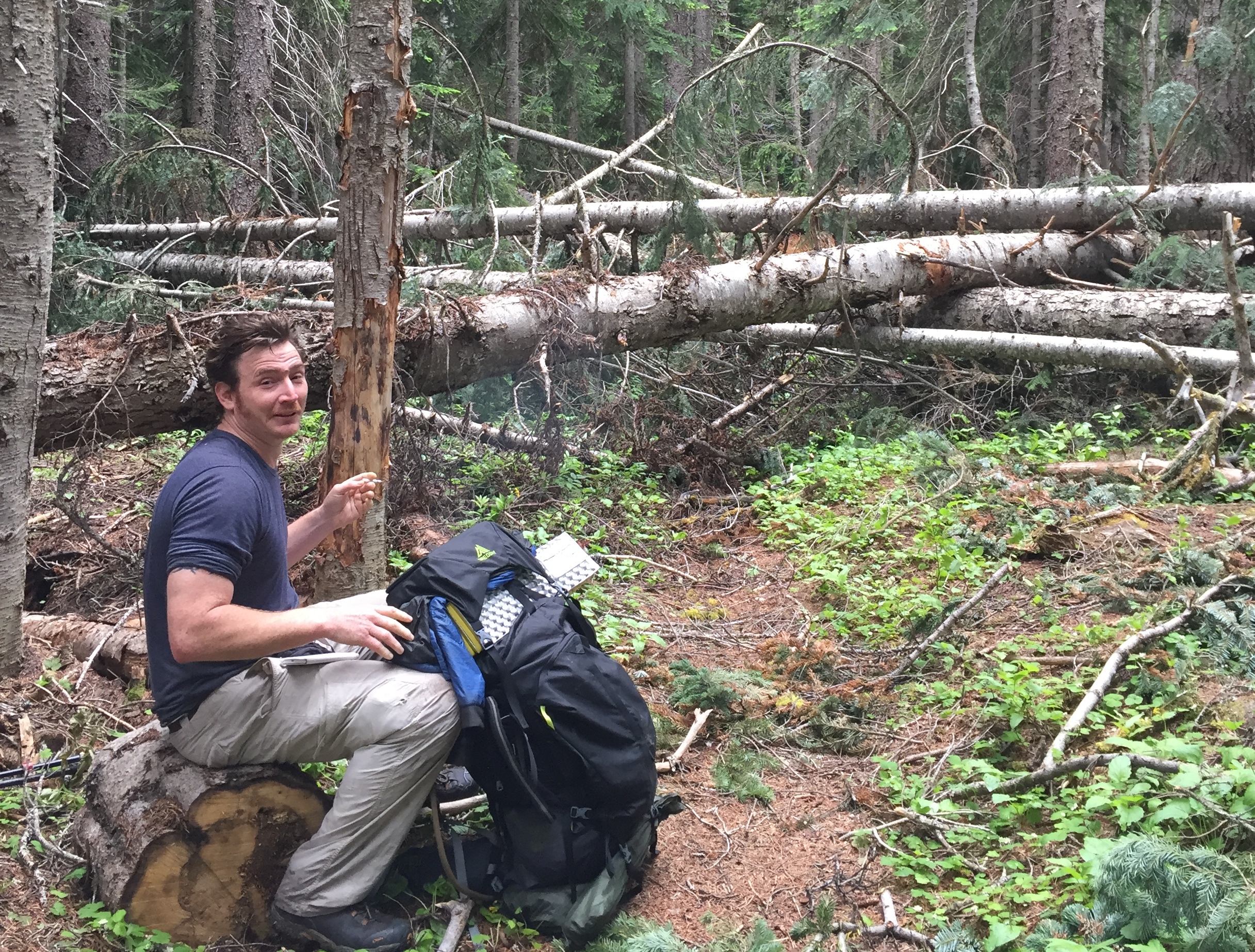
Karma Forward taking a break before a mile section of blow downs near the Methow River, north of Rainy Pass
The worst BLow downs
Blown down trees in Northern Washington are an absolute epidemic. This is one of the problems that SOBOs don't expect and consistently underestimate. This might be because by the time the NOBOs roll through, most of the trees have been cleared by trail crews. Quick thank you to the Washington Trail Assocation, and the North 350 Blades, who kick butt clearing trail in difficult country. Please think about volunteering with these groups before or after your thru-hike.
It's hard to know where the largest trees will fall, or what sections of trail will be worst affected. A lot depends on winter storms and where trees have fallen in previous years. It's safe to expect significant blow downs between the US/Can border and Rainy Pass, and between Stehekin and Snoqualmie Pass.
Climbing over trees all day will affect your pace and put a lot of stress on your muscles and joints. Go slow, take off your pack if necessary, and be careful. Most of the time the blow downs will be sporadic, every 500 feet or more. But in some places there will be a concentration of trees, almost like dominoes where one tree knocks over another, which knocks over another, and so on all winter long. In 2016 those worst sections were the 18 miles between Brush Creek and Rainy Pass, the 40 miles between S Fork Agnes River and Mica Lake in Glacier Peak Wilderness, and the 20 miles between Waptus Burn Trail and Ridge Lake just north of Snoqualmie Pass.
River Crossings
As a SOBO the river crossings you'll encounter in Washington and Oregon are much less dangerous than what NOBOs face in the Sierra. If it looks like a crossing is difficult just spend a minute looking upstream and downstream. Most likely there will be some kind of downed tree or limb that can be used to cross. And make sure you phone is in a secure place and in a waterproof plastic bag just in case! If there isn't a way to cross without getting wet, be careful if you decide to take off your shoes for a crossing. You can easily cut your foot on a submerged rock. Most hikers have light-weight shoes that dry quickly and they don't take them off for water crossings. Even if your light-weight shoes end up submerged in a stream, they'll likely dry within an hour.
MOSQUITOES
The moment the weather starts being consistently warm you'll have a bunch of new friends on the trail - mosquitoes. It's likely that you'll face an annoying amount of mosquitoes from about Stevens Pass in Washington to Crater Lake in Oregon. Hikers do a million different things to guard against these nefarious buzzers. Most popular is some sort of insect repellent, long sleeves/long pants (or simply just your rain gear), a head net or upper body net, or jumping in your tent as soon as possible once making camp. Other than covering your body with clothes or repellent, mosquitoes don't love the heat, so sitting in direct sunlight during a break can be a simple way to ward off the swarms. As most thru-hikers don't build campfires, that's rarely used as a method to stop the bugs. Be strong! Bites usually itch for a bit and quickly go away, though it depends heavily on the person. Usually mosquitoes are more of a mental challenge than anything as the incessant buzzing can be very frustrating.
Meeting NOBOS
A few weeks into Northern Washington you'll start meeting northbound thru-hikers. Each will seem like a figure of Greek mythology, never tiring and making huge miles every day. It's a big contrast because at this point SOBOs will still be adjusting to the trail and these hiker pros will appear almost otherworldly. Don't worry! These are the best of the best. Once in Oregon things will even out, as most SOBOs will be in good shape by this point and the NOBOs you meet will be more normal hikers.
After Northern Washington the next big challenge will be The Sierra, more than 1,000 miles to the south. Read about those risks below.